
This image is titled "London and it's Environs- if Google Earth had a cultural bias setting". Disregarding the cultural bias setting (that in itself is another blog post!), this map rougly illustrates where the north-south divide is, in psychological terms, and that it is fairly obvious what is "south", and a vague bit is a "commuter belt" into the south (I assume this is the midlands, in this case a feeder state into the south), and the rest is The North. Note how Londoners prefer to be associated with NY and Paris! You probably have been involved in a debate about this, whether you like it or not. The BBC ran an article on it once, asking its audience whether the line even exists (http://news.bbc.co.uk/1/hi/talking_point/3852593.stm)! So, how does the north-south divide relate to archaeology, and is it all about a case of perspectives? I apologise that I confuse the north-south divide with the "London versus the rest of the country" divide, but I feel that there is a lot of overlap between the two issues. I will also state my biases; I come from a few miles from junction 17 of the M1; the "Watford Gap", often used as the psychological divider of the country, so I consider myself that most vague of British cultural phenomena, a "midlander"!
To begin with, how do you define the sides? The "Northerner", according to the Chambers Dictionary, is "a native of or resident in the north, especially of the Northern USA or the northern counties of England", while a "Southerner" only appears to apply to the US, not to England, although a "Midlander" is defined as "(a resident or local of the area) relating to or designating the central parts of England" (Chambers 2001)! Instantly this means that we have to define your identity not on a particular cultural phenomenon, e.g. all people of the north wear higher heeled shoes than the others, but by an arbitrary set of lines following the borders of counties, which are political units that were created mainly before or during the Norman conquest! Does this mean that William the Conqueror had a perception of the north-south divide?
The north-south divide has quite a history. This has been blamed on everything from Anglo-Saxon emigration patterns, Benjamin Disreali's book Two Nations (or Sybil) https://sites.google.com/a/sheffield.ac.uk/all-about-linguistics/branches/varieties-of-english/the-north-south-divide. If Helen Jewell is to be believed then the north-south line has been in existence for at least 700 years in it's modern form, and even Iron Age communties of over 2,000 years ago may have had some idea of this divide as well (Jewell 1994:8)! However, the Iron Age idea comes from Sir Barrington "Barry" Cunliffe, former Emeritus Professor at Oxford University for European Archaeology. Here's the thing though; where did his perspective of come from? was it the visit to some ruins of his uncle's farm in Somerset when he was nine? (http://en.wikipedia.org/wiki/Barry_Cunliffe#cite_note-3)? Did this give him the idea that the Romans were such a powerful influence on the south of Britain, even before invasion, using trade, cultural ideals etc., that simply because some tribes that happened to be closer to the Roman Empire and it's allies, i.e. the southern ones, it made them more likely to become "romanised"? This, as you can see, is a very controversial, and exhaustive, topic, which can be quickly refuted; many recent archaeological examples show that instead of british tribes being simply receptive to "Roman" ideas in the Iron Age, they were actually trading their own unique goods and ideas not just across the country, but also to Europe. so in that sense, Iron Age tribes may not have been divided into "countries" or territories as we know it now, but they were not necessarily a homogenous mass of one culture either. let's not forget Helen Jewell either- she is a retired professor from Liverpool University, http://books.google.co.uk/books?id=LO3LpJmBuzAC&pg=PA55&lpg=PA55&dq=helen+jewell+historian&source=bl&ots=_6hNuCT9Mv&sig=NswqWFCA1lHPWPV5rL53E1EFt10&hl=en&sa=X&ei=-k3sUaCwAorP0AW6jICQDg&ved=0CEkQ6AEwAw#v=onepage&q=helen%20jewell%20historian&f=false. Unfortunately I could not get a personal biography of her, so her perspective can only really be gleaned from her work.
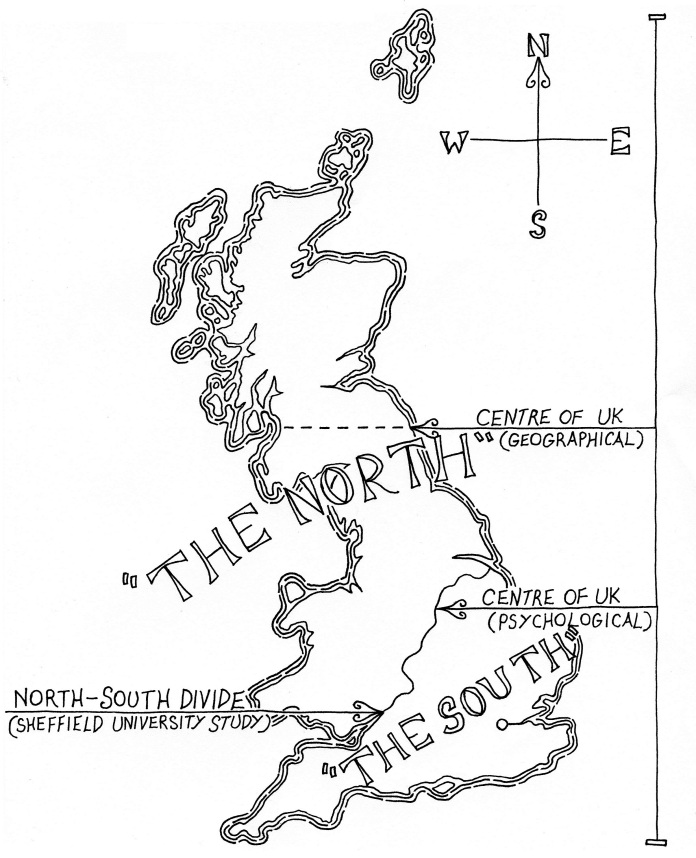
What about more contemporary academic studies? The image below is rather telling. It not only removes any notion of a "midlander", but also creates a more comprehensive and up to date dividing line http://www.sasi.group.shef.ac.uk/maps/nsdivide/ns_line_detail.html https://sasi.group.shef.ac.uk/maps/nsdivide/index.html. However, this map doesn't tell the whole story, as the study's authors admit: "" said ... . Is Leicester really southern?
But this is still missing out the one thing that has been missing from this debate so far; the midlands! The very political region that has been scruntinised in this article has not yet been given a voice. Do we, as midlanders, simply sit back and let a tug of war between the north and the south ensure?

So what's wrong with persepective? To begin with, if you can't reach a national concensus on what is the arbitrary line between north and south, then what is the point? Andrew Barr presents just two different ideas of what the north-south divide is in Britain; a true geographical one and the more famous "psychological" one, in addition to mentioning a study done by the University of Sheffield (see image below). In 1936, Cyril Fox, another archaeologist, made a similar conclusion to Barry Cunliffe and divided the country into lowland and upland archaeology, based purely on the surviving archaeological evidence! Even individual cities will claim their own north-south divides; a policeman told me once when people from the north of Coventry (e.g. Bablake) go into the south of Coventry (e.g. Earlsdon), they will sound to the Earlsdon folk like they've just come from Manchester; likewise, those from the south of Coventry going into the north of Coventry sound like they've lived in Oxford all their life*! If anything, I believe that this highlights a "melting pot" of the midlands culture; while sometimes we may yearn to be either northern or southern, we also like to creat a new identity out of this mixing of sides, which has been happening since when we started branding each other northerners and southerners.
So in conclusion, what have we learned about the north south divide? How much of it is perspective? how will future plans from Westminster affect this e.g. HS2? Will it bridge the divide, or will Westminster push the north away with a barge pole? If any MP's are reading this, then I would just like to confirm that the north-south divide almost certainly does exist; just go and walk through Coventry. Coventrians are proud of their accent and how it defines which part of Coventry they are from, and how this reflects on their "northerness" as a whole. Ignore the line at your peril.
P.S. Also, read this!
http://geologistinthedoctorwhoscarf.blogspot.co.uk/2013/07/this-weeks-geology-related-news-that-i.html
References:
BBC, 1st July 2004, Is there a north south divide? http://news.bbc.co.uk/1/hi/talking_point/3852593.stm, last retrieved 22/07/2013
The Chambers Dictionary, 4th edition, 2001.
Jewell, H.M., 1994, The North-South Divide: The Origins of Northern Consciousness in England, Manchester University Press, Manchester
Wikipedia, last updated 24/05/2013, Barry Cunliffe, http://en.wikipedia.org/wiki/Barry_Cunliffe#cite_note-3, last retireved 22/07/2013
Wikipedia, last updated 27/06/2013, Cyril Fox, http://en.wikipedia.org/wiki/Cyril_Fox, last retrieved 22/07/2013
Appendix:
Image 1: M@, last edited 21st March 2008, Touch Up London #83: How We Londoners View Our Neighbours, http://londonist.com/2008/03/touch_up_london_86.php, last visited 17th July 2013.
Image 2: unknown, last visited 22/07/2013
Image 3: Barr, A.M., last edited unknown, Londoncentric, http://andrewrbarr.com/maps/londoncentric/, last visited 17th July 2013.