Friday, 24 October 2014

Archaeological Techniques for the 21st century, part 2

This time, I will list a number of various technologies that are being used around the world by archaeologists to help with recording and interpretation! Thanks to the University of Swansea for the information from their department of Engineering and their Egyptology museum. The museum is free to visit and the website is here.


The U-CAT underwater camera

This underwater robot called the U-CAT , built at the Tallinn centre for Biorobotics, Finland, will help us to access shipwrecks! It looks like a small fish or submarine, it moves just like a sea turtle and it is only a few centimetres across. It carries It will be able to get into small cracks in submerged wrecks and buildings which would normally be inaccessible or unsafe for human exploration. It is also mounted with a camera, so a live feed could be accessed, and/or a digital reconstruction of the shipwreck can be created from the footage. The cost is not yet known, but surely the small size of the U-CAT means that it will be reasonably cheap to buy? As there are hundreds of submerged wrecks in the Solent channel alone, this could be a very useful resource to record and inform us about shipwrecks and submerged buildings and landscape in years to come.


Digitally recording archaeology on the cheap?

In archaeology, we can now create models in a number of situations, using cameras (for photogrammetric), laser scans (see previous post about laser scanning here), and even CAD (conmputer aided design) models! With companies like Agisoft and SketchUp providing the software to create models, he range of capabilites are vast. Currently some Universities are using SketchUp to archaeology students to improve the (digital) arcaheological record and the awareness in what software is available to arcaheologists.

www.sketchfab.com is a brilliant free service that allows you to publish 3D models, based on virtual reconstructions, which allows your work to be advertised to a wide audience. So long as you have access to the internet, you can then publish these models! If you upload your model into the SketchUp domain, then you can georeference your model to the real world!
A snapshot (from my postgraduate dissertation) of St. Faith's church in Google Earth, uploaded via SketchUp for free. The colour was added via photographs, except for the hexagonal tower, which has been modelled procedurally (that is, by using settings within the software) to avoid the need to use photographs).


Creating real-life plastic models of archaeology


A number of methods are now available for use for scanning artefacts, particularly X-ray scans. some Universities are pioneering the use of scanning technology for various materials, and then creating real life models out of them! For example, the University of Swansea has combined the use of a CT scanner, 3D visualisation technology and 3-D printers to create a model of a mummified round object from Egypt, about 50cm x 50cm x 60cm. It was assumed to be a baby or a small animal, but it turns out that it was the skeleton of a snake that was 80 cm long! It is difficult to date the snake, or tell what specific species it is based on this model alone, but it tells us that the Egyptians treated many animals with mummification. Why? Turns out that they revered many animals as sacred, not just cats! Many of their gods could metamorphose into animals, which then became sacred to them. This method is also non-destructive, and allows the object to be studied in the future, while the model can be handled by the public. The model on display, despite looking very small, is twice the size of the skeleton! This allows details in the skeleton to be explained to the public more clearly. Other institutions are practicing this too, such as the University of Southampton, who have used graphics software and 3-D printers to recreate the head from a marble statue found at the Roman port of Portus, near to Rome.

Friday, 11 July 2014

My festival of archaeology contribution! Exploring Leigh Park House, Havant in more detail

As part of the Festival of Archaeology (Friday 12th-27th July 2014) I'd thought I'd post about my current research! My project looks at Sir George Staunton's (as opposed to William Stone's) Leigh Park House, Havant, which is a grade II listed Regency and Victorian period mansion (c.1760-1860's), the only remnants of which today are the gothic library (see this post for my laser scans of the gothic library). It was mostly classical in it's architecture, except for the gothic library, which is often confused with a chapel (which is a fair cop). As the focal point of the Leigh Park estate, it was the starting point for any visitor to Leigh Park estate to visit the pleasure grounds which Garrett and Staunton had carefully nurtured over time, which was also the home of the lord of the manor of Havant and Flood. There are paintings of Leigh Park House, displaying its mostly classical character.
One of the drawings of Leigh Park House (courtesy of Chris Bailey)


But I am interested in the individuals who lived there and their reasons for altering the house. Our knowledge of the precise location of the house and its interior is also poor. It has been heavily rebuilt at least once, and the interior at least twice, while the story of its demolition has been given very little recognition to the development of the park. Furthermore, the house has had multiple occupants, but we don't really understand why they bought the property; was it for the views Leigh Park House afforded (as mentioned in poems, memoirs and other historical sources), or for other reasons?

I am currently using a series of geophysical techniques (magnetometry, resisitivity and ground penetrating radar) to investigate the below-ground remains of the house, while I am using a Geographical Information System (GIS) to investigate the buildings that have been claimed to have been seen from the estate. A GIS allows the user to investigate information via the medium of space; it is simply a database where all the information has a spatial component, and all the information is ordered into thematic layers, almost like layers of a cake! Furthermore, using historical sources, I want to reconstruct at least part of the interior of Leigh Park House, so we can better understand the House. These strands of evidence will be analysed to assess the reasons for living at Leigh Park House.
The RM15, a resistivity meter. By creating a circiut with two other probes in the vicinty, the resistance of the ground can be measured at certain points.


Ultimately, the reason for investigating Leigh Park House is to help the Staunton Country Park team take steps to conserve the remains of Leigh Park House and to make the reasons for the purchase of Leigh Park House and its alterations. The views offered from the the remains of Leigh Park House today do not give a lovely view of the sea, but give a view of some trees and some farm animals. My current idea is that there should be some sort of permanent display, detailing the interior of Leigh Park House, the reasons for purchasing it, and finally the views afforded from the house.

Thursday, 19 June 2014

A brief introduction to statistics and football

Time for another non-archaeological post!

I've noticed a trend this year, particularly on the BBC, to rely increasingly on "more sophisticated" statistical analyses as part of their commentary. Don't get me wrong, statistics can be useful but never have statistics been so obviously abused. It was about time that the book of "lies, damned lies and statistics" was thrown by the licence fee payer (i.e. you) at the BBC's sport section, and tell them off for making generalisations that either don't exist, or are just plain wrong.

N.B. I am not a Manchester United, Sunderland, or Chelsea supporter. Make what you will of it, but my good friends will be able to tell you that I support Coventry City Football Club. Having now stated my biases, lets get on with the stats.

So you have always had these fairly "basic" stats in the game, to do with possession, shots, fouls, and so on:

Match stats

Which are flawed in their own way, but fine, I can live with that. They're the obvious parts of a game. These are only used as a general indicator by most commentators, and don't rely on space as an argument (except for corners).  But now you're seeing this, which is my main concern:
Average position of players in Chelsea v Manchester United

Key to average position graphic


What is wrong with the mean in space (I hear you cry)?

The above map shows the average positions of the Chelsea players (on the left) and Manchester United players (on the right), based on something known as the central mean. the central mean, objectively speaking, is the sum of all of the positions the player was in, in a given space of time (e.g. the full 90 minutes, all the time before they were substituted on 75 minutes etc.), divided by the total number of positions they were in. Confused? Don't panic! Imagine you have a graph of x on the bottom, y on the top, and you work out the mean of the x and y separately (so as not to confuse them) e.g:


So then you reference them on the same map, giving you lines. Then you find where they meet, et voila! The mean centre has been found for that player over the time period. But, what does this actually tell you about each player? Does this mean that they stood rooted to the spot? Of course not (unless they are statues). The next map below illustrates the point about movement better:


Touches against Man Utd and heat map over last 10 Chelsea games

Key to touches and heat map
This heat map shows every touch made in the game made by two Chelsea players, and where they where as a percentage of the game. Look how dispersed the movement is! It's not just an up/down motion, it's sideways, it's all over the final third. In truth, it's similar to a lot of heat maps that you will come to see of a lot of attacking players in their positions. It would be interesting to see the mean centre of all those passes (and direction), although that would be even less useful than the mean centre of the player.

But where do these passes go? There are also maps to show the short and long passes, and where they were done in relation to the rest of the field. You can even tell which player they passed to the most, and who passes to who the most, and infer the in-field relationships from this.

But, ultimately, none of this actually tells you WHY a goal was scored, or a shot was blocked, and all the other football related reasons for winning or losing a game. Sorry, but there is no magic formula to win a game. Just hard work, being good, eating your vegetables and knowing far more about football than I do. These will all contribute to you scoring more goals than doing statistical analysis of every game and where they went wrong by using statistics alone. Also it will make you feel better that you can get more shots on goal by simply putting the practice in than just computing the most likely outcome.

Coming back to the problem of central mean, why is it a "forced marriage"? Means were not designed for space, only for quantities and other non-spatially defined stats.


Using statistics as the crux of his argument, you can see that he was right, but only in some respects, and not really being aided by his own diagrams. Yes, the Chelsea defence are relatively deep. But the statistics also show that Manchester's attack was actually in similar, deep, positions. So does this show that their pace was neutralised? Not really. The statistics show more likely that the offside trap was being used, and this is not a sign of pace, more tactical and player awareness. Furthermore, both sets of players are likely to be running around, for corners, free kicks and so on, so this will "skew" the results, so the mean may not actually reflect the "true" position of the player at all!! To quote Savage from the same article; "United were all over the place positionally for the second goal after clearing Chelsea's initial corner." This will affect the mean, but furthermore this incident that led to a goal is in no way reflected by the central mean. The speed is beneficial if you want to beat the offiside trap, but that's only half the battle.

So part of the problem is trying to use statistics to explain your point, and knowing how to use it. None of these stats can actually depict the game's movements. It is better for the commentator describe to you what caused the goal, or even better, go watch the actual game itself, if you want to know how to win games and have entertaining football!!

Summary

Statistics should only be used to explain the team game; the more components you add to a statistical analysis, the more it relates to the whole, and less to the individual players (if that makes sense). It should be noted that statistics are useful, but not as an argument unto themselves.


All images from League cup semi final between Manchester United and Sunderland, 22/01/2014, http://www.bbc.co.uk/sport/0/football/25849087, or from analysis of premier league game between Chelsea and Manchester United, 19/01/2014, http://www.bbc.co.uk/sport/0/football/25802415

Thursday, 29 May 2014

Creating a 19th century virtual walkthrough of the Gothic Library, part 3: Out of the frying pan and into the fire (more modelling, textures and lighting)

Thanks to Gianna, Grant and Peter for help on this section!!

The last time we left the model, the walls had been constructed, the windows had been given some properties so the impending sunlight would react to it in a physically accurate manner, but the painters and plasterers have not yet been called in. Well, now it's time to break out the Dulux colour charts (or the munsell colour charts, if you're more used to those)!

However, it turns out that my previous creation was very complex to map (more on that below), and it left too many gaps between the areas where the walls meet (for all that AutoCAD and 3DS Max share a lot of features, they are still two very different creatures) so it had to be completely rebuilt! This involved creating a box, splitting it into multiple segments and then model each individual window pane based on this box. Additionally it also turns out that the boolean functions (adding and subtracting surfaces and solids from each other to create new shapes) doesn't work very well in 3DS, in contrast to AutoCAD. I wasted 2 days trying to think of a workaround to this!! on top of the the box was too space intensive so I ignored the thickness of the walls and worked on a plane instead. This meant that I had to create a single shape (i.e. the planes) and effectively have ready-made holes in the shape.
This was repetitive, tedious and dull but it can at least be copied around the building, because the glass is a reasonably uniform shape. The other advantage is that I could import images of the building in question to create the glass panes and iron bars accurately, along with the rest of the model.
The segments and window in perfect harmony.

In 3DS, applying textures is like adding a new layer of wallpaper to a wall. It doesn't matter what the property of the object is, be it bricks, plastic, etc. If it has a surface, you can put a texture to it (and sometimes multiple textures)! These are known as "maps" and in this blog post I will go through my thought process as I show you how I added some more colour to the gothic library. In trying to be historically accurate, some of the photos have been edited to look how they would have done in the early 1830's, when the library had just been built.

I took some photographs of the gothic library (with the kind permission of Chris Bailey and the team at the Sir George Staunton country Park) and proceeded to edit these in Photoshop. In many places the beautiful plaster work had fallen off, and even some of the bricks had fallen out of place! However, I hadn't come to rebuild the library in real life, I've come to model it to see how it would have looked like in the 19th century, so I used some guesswork and historical evidence (see below) to ensure that the plaster was restored in it's virtual environment.
You can clearly see where the plaster should fill around the windows, but it has fallen apart with time.

The most difficult part about applying the photographs to the walls was thinking about how to "wrap" or map the photos around the object. Confused? Think of maps like wrapping a present, except that your present is a wall, and all of the wrapping paper must connect up together. The easiest things to wrap in the real world are those without curves, so the gothic library, if we only focus on the wall and not the windows, is fairly straightforward, especially if we only focus on the interior (i.e. a 2-dimensional surface). See the image of a dice below to see what I mean! Therefore, I changed the boxes that represented the walls into single, 2-dimensional elements by breaking them and then grouping the resulting elements together. A similar texture was used for the roof, which was already in 2- dimensional pieces. The floor, on the other hand, would not require quite as much thought as it was created as just one object. However, to the inexperienced user of 3DS Max, it is a daunting task!

Each of these boxes represents a part of the property of the fabric of the building, be it the texture, the colour, glossiness, etc.


This dice is easy to apply to a surface in 3DS because it is geometrically quite straightforward.

As you can see this is one way of applying a photorealistic texture to the building. However, this doesn't cover all of the texturing! The different "maps" don't just cover what you can see on the surface; you can adjust transparency, bumpiness, shadow, photons, etc. Many of these maps are to do with how light reacts with the surface. Unfortunately, I ran out of time to play around with these different maps!

Friday, 16 May 2014

Creating a virtual 19th century walkthrough of the Gothic Library, part two: The creation of the model

The story so far:

I have been assigned the task of creating a virtual model for a TV show about Victorian architects. This will involve using 3DSMax to add textures and show how light entered the building. But first, I have to actually create the model!

One of the problems is that the model needs to be be accurate. Fortunately, I have a point cloud (from a laser scanning device) of the gothic library (see my other blog about how I came into possession of this data), which I can use to create the model. However, a point cloud is computationally very expensive, so it takes a long time to create the model, but more importantly, I can't import the point cloud into 3DSMax as it can't support point clouds (yet!). Therefore, my first problem is finding a software program that I can use to help creating an accurate model of the library. since the point cloud is incomplete as well as not being supported in 3DSMax, I will have to use the point cloud as a guide, and build polygons manually in a program like AutoCAD. AutoCAD, being made by Autodesk, who also make 3DSMax, there is a lot of compatibility between the two programs. For a start, they can both work in either 2-D or 3-D shapes, although the way they are constructed varies (AutoCAD is used more for designing buildings and complex mechanical parts, 3DSMax focuses more on smaller scale models for game engines etc.).


Shaded and wireframe views of the gothic library so far... the walls will be textured (given colour, physical properties) etc. when the model is finished.


However, the time spent in AutoCAD limited how much time could be spent in 3DS Max, which is a factor because 3DS Max is very time-consuming. Furthermore it was decided only to focus on the construction of the windows, and then the point cloud would be used to take images of the rest of the interior. These images will form the basis of the textures which will be rendered inside the library. This differed from the original plan of digitising every element inside the gothic library using autoCAD as this would be even more time consuming(!), as well as cutting down on the time spent digitising. Once the main model was built out of the point cloud, the rest of the model could be created in 3DS Max, using the edit poly feature from the modifier list to add elements and features which had not been included in the model. this additional editing in 3DS MAx took a little while longer than expected but with practice, the speed of modelling starts to improve.

Next time: texturing and lighting!

Tuesday, 6 May 2014

Creating a virtual 19th century walkthrough of the Gothic Library, Sir George Staunton Country Park, Havant, part one

N.B. this is a project that I am working on for my Southampton University course and the final results will not be used in real life unless otherwise mentioned. All similarities to the real world, except for anything relating to the Gothic Library, Lewis Vulliamy and all property relating to Autodesk (3DS Max, AutoCAD, etc.), are purely coincidental.

I have been assigned the task of creating a virtual "walkthrough" of the Gothic Library, Havant, for a new TV documentary, as part of a series looking at inspirational Victorian architects. Why the Gothic library? Because it was designed by Lewis Vulliamy, who designed a large number of ecclesiastical and secular buildings in innovative styles in the early Victorian era, and the library's appearance has changed dramatically over the last 150 years.  The Gothic started out life as a library, housing Chinese manuscripts and books of Sir George Staunton, but today very few of the Gothic elements of the library remain; indeed, it is often mistaken for a chapel than a library! This confusion arises from a lack of information about what it's original purpose was for, because it's external appearance (which is largely unchanged) is that of a Gothic revival from the early 19th century, similar to that of many churches across England. While the architect who designed it, Lewis Vulliamy, also designed churches in a similar style, the interior of the Gothic library showed off his flair and creative ability. There is historical  documentation to show what the Gothic library looked like, so part of the assignment will incorporate this.

So what do I mean by a "walkthrough"? The TV company want a video that shows how someone would move around the space of the library, back when it was in use. This would include the furnishings, such as the bookshelves, the original fireplace, etc. so this will take the form of an animation to look at some of the features that existed within the library, but have now been removed. Furthermore, these can be compared to the modern features which have replaced them, in particular the windows, which used to contain more stained glass.

Furthermore, a "walk through" would need to combine the archaeological and virtual elements together seamlessly so that it looks real. This is not as easy as it sounds! While the physical properties of light, bricks, books and so on can be recreated accurately within the software (in this case, 3DS Max (made by Autodesk), this doesn't necessarily mean that it will look realistic. So a balance must be struck between realism and physical accuracy. It is very easy to break the laws of physics in these bits of software.

Furthermore, it has been noted that the actual library may not have been a particularly good place to study, because of the windows letting in either too much or too little light, due to their position relative to the sun. This can be tested using 3DS Max and Mental Ray, which can calculate the position of the sun depending on your position on the earth and the time. This will allow us to see whether the windows impeded reading in the room, and whether it could actually be used as a library.

So I will use 3DS Max (and AutoCAD) to:


  • Reconstruct the Gothic library, as it looked like in it's heyday of the 1830's-1860's, complete with windows, bookcases and possibly the roof, using the laser scan data as a basis for the model, and supplement it with other historical documents.
    The main laser scan data, which has been imported as a point cloud from a FARO X330 and processed in various pieces of software (see my other blog for more information)
  • Analyse whether the light intensity would have been too great or too little for reading, or performing other related activities.
The original interior of the Gothic library, complete with the spectacular roof. I will try to recreate this as faithfully as possible!

The results of these will be animated using 3DS Max, and combined with a series of stills, will go into the TV documentary. Stay tuned for updates!

Monday, 28 April 2014

Laser scanning Sir George Staunton Country Park

So the other day I was able to get hold of a FARO Focus X330 and use it to record some archaeology! The FARO Focus is a top-end machine; as the name suggests it can fire lasers over 330 metres away and still receive the returning beam, in a 360 degree arc. It can be used by one person, as it is quite light and is about the size of a small suitcase. It also doesn't take very long for it to capture millions of data points, which provide an accurate reflection of a building/artefact. These can be downloaded and "stitched" together to create a 3-dimensional model (for info on how to create 3-d models and some software to use them, see my previous blog).


So why was I surveying some buildings for archaeology? More precisely, I haven't told you what I was surveying! I surveyed the Gothic Library and the Beacon at the Sir George Staunton Country Park in Havant, near Portsmouth. To those who are not familiar with Sir George Staunton Country Park, it is named after Sir George Staunton, who built up the estate with land purchases over a number of years and created the "pleasure grounds" to house his exotic plants and later his memorials (read on below for more info). The buildings in question are two late Regency-period buildings (both constructed in the 1830's), and the Library was one of the first Regency buildings in Britain to exhibit gothic features. It is octagonal in shape, and has lovely pointy bits on the edges of the roof, plus one very tall chimney on one of these edges (possibly related to the old fireplace inside). It used to be connected to Sir George Staunton's mansion, who was an important British ambassador to China in this period, particularly given the Opium wars of the 1830's which made it even more difficult to acquire Chinese literature. It was illegal for Chinese officials to teach Chinese, or give Chinese writings to foreigners, so it becomes all the more impressive to know that Sir Staunton translated the first law books from Chinese into English, and was one of the founding members of the Royal Asiatic Society! The Library's walls alternate between mortar and brick faces, so I wanted to capture this in detail, to see how they might relate to the old mansion. However, you are also allowed inside the library, and so I wanted to capture any features that may give us evidence that this was used as a library, such as old beams for bookcases, etc. The floor plan of the mansion is very sketchy, and there might have been a second library inside the mansion that was never mentioned...
Wikipedia's image for the gothic library.


The gothic library as a raw scan. Note how some of the bottom is missing, that's because there are some hedges in the way!


This is a shot of the raw scan of the gothic library's interior, and compared to the photo below, it's fairly accurate, capturing all the detail on the walls (except for the windows, which look like a bullet has just gone through it)!


The Beacon, on the other hand, was constructed from the remains of a nearby mansion (Purbrook house), and is entirely coated in mortar, with a brick base. A circular veranda It was built by the same architect who designed the Gothic Library, Lewis Vuillamy and represents a very different side to the architect; the Library was a modern, ahead of it's time structure that preceded the gothic revival, while the Beacon harked back to Ancient Greece and Italy (where he had travelled previously). Because the Beacon is so isolated, it is almost preserved perfectly. But more about that in a second...

Can you tell the virtual laser scan model (bottom) apart from the real thing (top)? This is after the data has been "cleaned up" with Pointools, one of the more common (yet expensive) software programs for point cloud edits!

I only needed to take as many scans as I needed (i.e. as many as would cover the buildings, since the scans will overlap). The roofs were very difficult to capture because they are blocked, but can be seen clearly from Google Earth!. So I ended up with 25 scans for both buildings, taking about 15 minutes each. This took the whole day, but no other technique could capture the data so accurately and precisely! A photograph doesn't give you coordinates like a laser scan does.

So when the data downloaded, it turned out that:

  1. The Gothic Library is structurally in good nick, but a lot of the exterior details didn't come out very well. This is because the hedges and trees got in the way, and there was nothing I could do about this! Only LIDAR penetrates trees and this can only be used on planes. Since you can't fly a plane this close to the ground, then this is the best result I could get in a day. 
  2. But, I was able to analyse the wall thickness, and it turns out there may be some interesting mathematical patterns in the buttresses supporting the library.
  3. The Beacon actually has one or two problems! The edge of the roof has been eroded by natural causes (birds and the weather), and a new hole has been found in the interior, which seems to have been caused by the natural building materials.
There are some other cool things you can do with the data, such as showing you the intensity of the point cloud (or where the laser scanner received the most information from). This can tell you things like how reflective a surface may be, especially if it's in an isolated place where you can't tell what material it's made out of, such as the roof of a cave deep underground.

At the end of the scanning and editing process, the scans can be taken into a different software package like Autodesk's ReCap or AutoCAD and digitised to have walls, windows and so on, adding more realism to the model.


One of the scans showing the intensity of laser points, showing where the laser scan picked up the most points off the walls (from multiple scan). Neat, eh? It looks more solid on one side and on the roof because 3 scans were taken of the gothic library, and these were unevenly distributed around the room.


So you'd be forgiven for thinking that laser scanning is a quick and expensive way of finding cracks in buildings! But it can also reveal new, previously unknown features about a building. The cost is coming down all the time, although at about £25,000, this isn't something that can be done on a whim! As always the right archaeological questions are required.

Saturday, 12 April 2014

3D Modelling for Archaeologists

In this blog post, I will show archaeologists what 3D modelling packages are, how they can be used, which ones to use and what I recommend for you!

Disclaimer: these software programs may not be free indefinitely, even if they are free at the time of print. There are many trials of products, such as Photoshop (useful for editing photos, which can be used in modelling), but much of the free software is also constantly being updated/ is freeware, and so may contain bugs, so it may not work properly.


Introduction

3D modelling software does what it says on the tin; it allows you to create 3-dimensional models (if you know autoCAD, you can skip straight to the software section below
). The applications are obvious; building models that can bring a new level of interpretation to your work and allow a new medium to be exploited, so the public can be more informed and enjoy your work much more easily. Modelling software developed out of architecture and mechanical engineering, where the accurate visualization of components that are often not fully visible need to be seen. But in recent years the line ha blurred as to where 3D modelling software stops; it can be seen in many aspects of life, in particular video games. Because of it's flexibility in so many aspects of the modern world, archaeology and heritage-related specific software, or even software that is remotely relevant to us, is difficult to come by (unless you're in the right place at the right time).

Critcisms

A lot of worries and criticisms I have discussed with fellow archaeologists is that there is not enough time to incorporate modelling into many projects, because either the software will not be supported, or the software has to be learned, and this will take time away from the project and actual excavation. These are valid criticisms, but for a project that involves a large and/or  public audience that will find this information online, I argue that a model created using free software will not take very long to learn, the time and financial costs involved are very low, and most computers will be able to handle simple models. Compared to software that you have to pay for (such as AutoCAD), many of these software packages are not very advanced, nor do they provide some of the measuring tools necessary for a detailed reconstruction. But, at a time when the world has been undergoing a social and technological revolution since the creation of the internet, archaeology is being left behind in the technological front. but as a compensation, while we have always taken the hand me downs to begin with, such is the rate of development, in this situation the "hand me down" is free and I recommend it to archaeologists the world over, not least because a lot of these software packages are compatible with each other, especially when it comes to publishing! 

However, one thing that will have to be considered when you build a model is how you actually, well, build it. some complex lines and geometries need to be "thought through" before you start building it up (see fig.1). For example, to build an angular roof that fits a circular building, you will need to think about how to create the height of the roof, and how to model any inconsistencies in the roof. This also leads to the question of just how much detail you want to put into the model (down to the individual brick, for example, or just the walls), which details will be left to the textures (think of textures as coasts of paint for buildings, but can be applied to anything)?


Fig.1: Start thinking outside the box to construct more complex shapes. Made in Sketchup (author's own).

Theory?

Theoretically speaking, where is archaeological modelling? the truth is, I don't think we actually know. Yes, it's dangerous to take archaeological models at face value, but where does the theory come into modelling?  With apologies to David Clarke, we need to "lose our innocence" over modelling. In particular with reconstructing an artefact/building that has been destroyed, there is an element of variability/probability/interpretation that needs to be considered and explained. Is the data reliable enough to allow for multiple reconstructions? Part of this topic is  known as "procedural modelling", and none of the below modelling software can accomodate this. So how do you accomodate differing interpretations?  I think this debate will grow organically as it takes up more space in the archaeological literature.

The Software

So on to the software!

At the beginning of your project (or even the thing that makes you start your project), you see an artefact/object that you think would look nice as a virtual model. This is my personal set of questions/ checklist for what you can model:

  • Can you photograph it from all angles freely (excluding the bottom, but would be nice if you could)?
  • If this isn't possible, can you get hold of more advanced techniques, like laser scanning, instead of photography?
  • Is it appropriate to create a virtual model of the object? If you're only going to use it for presentation, that fine, and these free applications are great, but you may not be asking the right archaeological questions if this is your primary focus. Ask the archaeological questions first, then think about how to model it.
  • Are there more appropriate methods available for what you want to model?
  • If this isn't possible, can you get some surveyed points of the object and hope to photogrammetrise it?
  • Most importantly, can it form the basis of your research question?
Here are the ones I recommend from his list, which vary in usefulness depending on your project/artefact. this is not an exhaustive list by any means, but a full list of free software technologies are on this blog:

  • SketchUp - very good for starting out on modelling in general, but doesn't contain many advanced functions in the free version. Because it is so simple, it is very easy to model large areas quickly, without using up much disk space. You can also add some textures, so a very convincing model can be built up quickly. It is better for modelling buildings, rather than smaller artefacts. It also doesn't allow you to import photos, but it can import snapshots of, and georeference to, Google Earth! as a results, it is very tempting to show excavations or known positions of buried features alongside standing features. Combined with it's own online depository, this means that it is very easy to find multiple models very easily. The greatest problem is when complex architecture (such as creating a finial, see fig 3 below) or smaller artefacts. There is also very in the way of photogrammetric functions. BUT, my main criticism is what Google will do with the data, particularly once it is on their depository (Google sold SketchUp in 2012 to Trimble, but Google still release a free version). Will your model put on Google Earth without your permission, for example? In this increasingly Big-Brother style world that Google is turning us into, are we unwittingly giving Google the very data it needs to accomplish such a task?
 fig.2: A work in progress of the gothick Library, Sir George Staunton Country Park, Havant. the simplicity of the model allows for rapid creation with limited data; this was the first time I used Sketchup, and it only took me an hour to make the building (author's own)!


Fig.3: Photo of the Beacon, Sir George Staunton Country Park, Havant. The finial is the metallic decoration on top, full of complex curves that could not be done through Sketchup, unless you were able to reach the top of the roof and measure all the survey points (author's own)!
The main modelling software packages I recommend are:
  • FreeCAD- this requires more knowledge to work than Sketchup, because FreeCAD can implement advanced motion simulation capabilities, so you can do some fancy things, like make a moving water wheel. It is not as intuitve as Sketchup though.
  • 123D catch and make- This is a suite of programs made by a large company (AutoDesk), they has an interface similar to autoCAD; i.e. they have a viewcube, the mechanics are reasponably intuitive too (although if you haven't used autoCAD, then SketchUp may feel more intuitive). It works mainly with dwg files made by autoCAD.
The main photogrammetric software packages that I recommend are:
  • Cultural Heritage Imaging have been pioneering unique photogrammetric techniques in the USA, and their free software is called Reflectance Transformative Imaging (aka RTI). As it has been specifically designed with cultural heritage specialists and archaeologists in mind. However, if you have never used photogrammetric techniques before, then it is worth going over to their website and reading their manual, because it has two programmes that you can download. The methods employed are easy to understand, but the steps in the program (RTIviewer) tend to feel a bit dislocated from the process of actually stitching the photos! Don't worry, this happens, and if you follow the instructions in their manual, you will get a results. This is probably the best photogrammetric software; however, it is highly recommended to read their website first and then employ their methodology (instead of their capture kit, you can get similar results, using a shiny ball, string and  a tripod for most artefacts/ faces). So this software requires the most planning too, but the results are worth it. One example of RTI being practised in the UK is the Saving Your Cemetery or Church in York.
  • 123D catch-autodesk's photogrammetric software. I haven't tried this, so I can't give my opinion!
Finally, to publish your model online for free, there are on or two ways of doing this. Some archaeologists are using sketchfab, which can upload over 25 file types of models (except for .dwg files from AutoCAD). This also exemplifies the multivocality of modelling; event though you have large Trans-National Corporations involved in this market, there are a huge number of very popular software packages, which are largely inter-compatible, allowing archaeologists to do what we want to do, particularly when it comes to publishing models!

So to summarise, if you think that you could model a building, the chances are that there will be a software package for you, that will be free, easy to learn, can be downloaded to your home PC. SketchUp is recommended if you don't mind sharing your models, but other freeware is available, that can do the job just as well.

Thursday, 9 January 2014

The North South Divide: A case of perspectives?

While doing some research on the Lindisfarne Gospels for an essay last year, I came across this image, which got me thinking about it's wider implications for the north-south divide:

 how Londoners view the world

This image is titled "London and it's Environs- if Google Earth had a cultural bias setting". Disregarding the cultural bias setting (that in itself is another blog post!), this map rougly illustrates where the north-south divide is, in psychological terms, and that it is fairly obvious what is "south", and a vague bit is a "commuter belt" into the south (I assume this is the midlands, in this case a feeder state into the south), and the rest is The North. Note how Londoners prefer to be associated with NY and Paris! You probably have been involved in a debate about this, whether you like it or not. The BBC ran an article on it once, asking its audience whether the line even exists (http://news.bbc.co.uk/1/hi/talking_point/3852593.stm)! So, how does the north-south divide relate to archaeology, and is it all about a case of perspectives? I apologise that I confuse the north-south divide with the "London versus the rest of the country" divide, but I feel that there is a lot of overlap between the two issues. I will also state my biases; I come from a few miles from junction 17 of the M1; the "Watford Gap", often used as the psychological divider of the country, so I consider myself that most vague of British cultural phenomena, a "midlander"!

To begin with, how do you define the sides? The "Northerner", according to the Chambers Dictionary, is "a native of or resident in the north, especially of the Northern USA or the northern counties of England", while a "Southerner" only appears to apply to the US, not to England, although a "Midlander" is defined as "(a resident or local of the area) relating to or designating the central parts of England" (Chambers 2001)! Instantly this means that we have to define your identity not on a particular cultural phenomenon, e.g. all people of the north wear higher heeled shoes than the others, but by an arbitrary set of lines following the borders of counties, which are political units that were created mainly before or during the Norman conquest! Does this mean that William the Conqueror had a perception of the north-south divide?

The north-south divide has quite a history.  This has been blamed on everything from Anglo-Saxon emigration patterns, Benjamin Disreali's book Two Nations (or Sybil) https://sites.google.com/a/sheffield.ac.uk/all-about-linguistics/branches/varieties-of-english/the-north-south-divide. If Helen Jewell is to be believed then the north-south line has been in existence for at least 700 years in it's modern form, and even Iron Age communties of over 2,000 years ago may have had some idea of this divide as well (Jewell 1994:8)! However, the Iron Age idea comes from Sir Barrington "Barry" Cunliffe, former Emeritus Professor at Oxford University for European Archaeology. Here's the thing though; where did his perspective of come from? was it the visit to some ruins of his uncle's farm in Somerset when he was nine? (http://en.wikipedia.org/wiki/Barry_Cunliffe#cite_note-3)? Did this give him the idea that the Romans were such a powerful influence on the south of Britain, even before invasion, using trade, cultural ideals etc., that simply because some tribes that happened to be closer to the Roman Empire and it's allies, i.e. the southern ones, it made them more likely to become "romanised"? This, as you can see, is a very controversial, and exhaustive, topic, which can be quickly refuted; many recent archaeological examples show that instead of british tribes being simply receptive to "Roman" ideas in the Iron Age, they were actually trading their own unique goods and ideas not just across the country, but also to Europe. so in that sense, Iron Age tribes may not have been divided into "countries" or territories as we know it now, but they were not necessarily a homogenous mass of one culture either. let's not forget Helen Jewell either- she is a retired professor from Liverpool University, http://books.google.co.uk/books?id=LO3LpJmBuzAC&pg=PA55&lpg=PA55&dq=helen+jewell+historian&source=bl&ots=_6hNuCT9Mv&sig=NswqWFCA1lHPWPV5rL53E1EFt10&hl=en&sa=X&ei=-k3sUaCwAorP0AW6jICQDg&ved=0CEkQ6AEwAw#v=onepage&q=helen%20jewell%20historian&f=false. Unfortunately I could not get a personal biography of her, so her perspective can only really be gleaned from her work.

What about more contemporary academic studies? The image below is rather telling. It not only removes any notion of a "midlander", but also creates a more comprehensive and up to date dividing line http://www.sasi.group.shef.ac.uk/maps/nsdivide/ns_line_detail.html https://sasi.group.shef.ac.uk/maps/nsdivide/index.html. However, this map doesn't tell the whole story, as the study's authors admit: "" said ... . Is Leicester really southern?

But this is still missing out the one thing that has been missing from this debate so far; the midlands! The very political region that has been scruntinised in this article has not yet been given a voice. Do we, as midlanders, simply sit back and let a tug of war between the north and the south ensure?


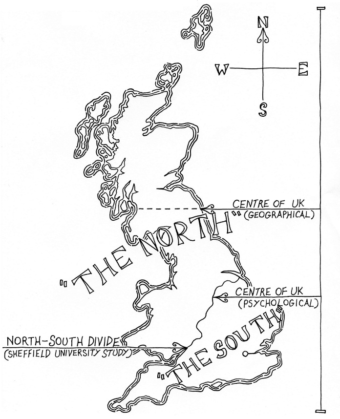
So what's wrong with persepective? To begin with, if you can't reach a national concensus on what is the arbitrary line between north and south, then what is the point? Andrew Barr presents just two different ideas of what the north-south divide is in Britain; a true geographical one and the more famous "psychological" one, in addition to mentioning a study done by the University of Sheffield (see image below). In 1936, Cyril Fox, another archaeologist, made a similar conclusion to Barry Cunliffe and divided the country into lowland and upland archaeology, based purely on the surviving archaeological evidence! Even individual cities will claim their own north-south divides; a policeman told me once when people from the north of Coventry (e.g. Bablake) go into the south of Coventry (e.g. Earlsdon), they will sound to the Earlsdon folk like they've just come from Manchester; likewise, those from the south of Coventry going into the north of Coventry sound like they've lived in Oxford all their life*! If anything, I believe that this highlights a "melting pot" of the midlands culture; while sometimes we may yearn to be either northern or southern, we also like to creat a new identity out of this mixing of sides, which has been happening since when we started branding each other northerners and southerners.


Londoncentric


So in conclusion, what have we learned about the north south divide? How much of it is perspective? how will future plans from Westminster affect this e.g. HS2? Will it bridge the divide, or will Westminster push the north away with a barge pole? If any MP's are reading this, then I would just like to confirm that the north-south divide almost certainly does exist; just go and walk through Coventry. Coventrians are proud of their accent and how it defines which part of Coventry they are from, and how this reflects on their "northerness" as a whole. Ignore the line at your peril.


P.S. Also, read this!
http://geologistinthedoctorwhoscarf.blogspot.co.uk/2013/07/this-weeks-geology-related-news-that-i.html

References:
BBC, 1st July 2004, Is there a north south divide? http://news.bbc.co.uk/1/hi/talking_point/3852593.stm, last retrieved 22/07/2013

The Chambers Dictionary, 4th edition, 2001.

Jewell, H.M., 1994, The North-South Divide: The Origins of Northern Consciousness in England, Manchester University Press, Manchester

Wikipedia, last updated 24/05/2013, Barry Cunliffe,  http://en.wikipedia.org/wiki/Barry_Cunliffe#cite_note-3, last retireved 22/07/2013

Wikipedia, last updated 27/06/2013, Cyril Fox, http://en.wikipedia.org/wiki/Cyril_Fox, last retrieved 22/07/2013

Appendix:

Image 1: M@, last edited 21st March 2008, Touch Up London #83: How We Londoners View Our Neighbours,  http://londonist.com/2008/03/touch_up_london_86.php, last visited 17th July 2013.

Image 2: unknown, last visited 22/07/2013

Image 3: Barr, A.M., last edited unknown, Londoncentric, http://andrewrbarr.com/maps/londoncentric/, last visited 17th July 2013.